Crooked forest

There are many theories on the mystery, although there is little to no evidence to support any of them. Some hypothesize that a unique gravitational pull in this particular area caused the trees to grow curved northwards, but this theory does not hold up to basic scientific scrutiny given that gravity pulls things downward and not at a curve. Others guess that the heavy snowfall in the area weighed down the trees as they were sprouting, causing them to grow crookedly at the base, but this theory does not explain why other groups of pine trees and assorted vegetation in the same area were not affected. Some suspect that the trees were grown for the rims of wooden cartwheels as the grain direction would have produced very tough wheels. The most widespread and most likely explanation is that local farmers planted and manipulated the trees when they planted them in 1930, but it is estimated that the trees were seven to ten years old when they experienced the force that resulted in trunk curvature. when they experienced the force that resulted in trunk curvature.

The Crooked Forest is a grove of 400 oddly shaped pine trees located near the town of Gryfino, West Pomerania in Poland. The pine trees were planted around 1930 when its location was still within the German province of Pomerania.

From the base, the pine trees grow with a 90-degree sharp bend northward, but then curve back to grow straight up into the sky. Despite the unnatural curves bending three to nine feet sideways at their bases, these trees are generally healthy and grow up to 50 feet tall.

Were the trees intentionally altered local farmers? Did the trees naturally bend northwards? Many people have been trying to find an answer to this mystery, but since the town of Gryfino was largely abandoned between the early stages of World War II until the 1970s, the people who were there before the war and probably had the answer to the mystery of the Crooked Forest are now likely gone forever.

For more information :

The Mystery of Aragats

Last couple of years many people travel to Mount Aragats in Armenia, to see the unexplained phenomenon that contradicts all of the laws of physics with their own eyes. The mystery of Aragats lies in the gravity hill that is situated there. It attracts many people from all over Armenia and around the world.

Gravity hill research

There are many guesses and theories about the mystery of Aragats. What is happening in this place, and how is it possible? Some people think that this is a deformation of gravitational field, while others think that there are some special magnetic fields here. Some even tend to believe in the existence of aliens and the landing of UFOs in this area. And some people have a simpler explanation – an optical illusion, due to the absence of the horizon. Whatever is happening here, it attracts many people, and each one of them has a right to believe in what is more reasonable for them.

Hiking Mount Aragats | Highest Mountain of Armenia

Gravity laws are canceled

In seems like in this small area the laws of gravity decided to disappear. Here, the water in the river flows from the bottom to the top. When you put car on neutral, it automatically goes uphill, without any driver. If you put a bottle on the ground, it will again roll uphill. Walking up the hill feels easier than walking down.

There are many gravity hills like this in many parts of the world, and Armenia is no exception. The mystery of Aragats was revealed recently. On the Internet you can find countless videos in which people captured this unusual phenomenon. It is located on the highway leading to the 7th century fortress Amberd, at an altitude of about 2000 m above sea level. Seems like this gravity hill became a new stop for curious travelers, and for Armenians as well.

For more information :

Aokigahara

WARNING – this topic might contain sensitive content.

Aokigahara, also known as the Sea of Trees, is a forest on the northwestern flank of Mount Fuji on the island of Honshu in Japan, thriving on 30 square kilometres (12 sq mi) of hardened lava laid down by the last major eruption of Mount Fuji in 864 CE. The western edge of Aokigahara, where there are several caves that fill with ice in winter, is a popular destination for tourists and school trips. Parts of Aokigahara are very dense, and the porous lava rock absorbs sound, contributing to a sense of solitude that some visitors attribute to the forest.

The forest has a historical reputation as a home to yūrei: ghosts of the dead in Japanese mythology. At least since the 1960s, Aokigahara has become associated with suicide, eventually becoming known in English by the nickname “Suicide Forest” and gaining a reputation as one of the world’s most-used suicide sites. Because of this, signs at the head of some trails urge suicidal visitors to think of their families and contact a suicide prevention association.

Aokigahara is sometimes referred to as the most popular site for suicide in Japan. In 2003, 105 bodies were found in the forest, exceeding the previous record of 78 in 2002. In 2010, the police recorded more than 200 people having attempted suicide in the forest, of whom 54 completed. Suicides are said to increase during March, the end of the fiscal year in Japan. As of 2011, the most common means of suicide in the forest were hanging or drug overdose. In recent years, local officials have stopped publicizing the numbers in an attempt to decrease Aokigahara’s association with suicide.

The rate of suicide has led officials to place a sign at the forest’s entry urging suicidal visitors to seek help and not take their own lives. Annual body searches have been conducted by police, volunteers, and journalists since 1970.

The site’s popularity has been attributed to Seichō Matsumoto’s 1961 novel Nami no Tō (Tower of Waves). However, the history of suicide in Aokigahara predates the novel’s publication, and the place has long been associated with death; ubasute may have been practiced there into the nineteenth century, and the forest is reputedly haunted by the yūrei of those left to die.

For more information :

El Dorado

El Dorado, which translates to “the golden”, is commonly associated with the legend of a gold city, kingdom, or empire. Originally, El Hombre Dorado (“The Golden Man”) or El Rey Dorado (“The Golden King”), was the term used by the Spanish in the 16th century to describe a mythical tribal chief or king of the Muisca people, an indigenous people of the Altiplano Cundiboyacense of Colombia, who as an initiation rite, covered himself with gold dust and submerged in Lake Guatavita.

A second location for El Dorado was inferred from rumors, which inspired several unsuccessful expeditions in the late 1500s in search of a city called Manoa on the shores of Lake Parime or Parima. Two of the most famous of these expeditions were led by Sir Walter Raleigh. In pursuit of the legend, Spanish conquistadores and numerous others searched what is today Colombia, Venezuela, and parts of Guyana and northern Brazil, for the city and its fabulous king. In the course of these explorations, much of northern South America, including the Amazon River, was mapped. By the beginning of the 19th century, most people dismissed the existence of the city as a myth.

The legend of the Seven Cities of Gold (Seven Cities of Cibola) led to Francisco Vázquez de Coronado’s expedition of 1540 across the New Mexico territory. This became mixed with the stories of El Dorado, which was sometimes said to be one of the seven cities.

El Dorado is a real mystery, because we don’t even know if it’s real or not.

For more information :

Bhangarh Fort

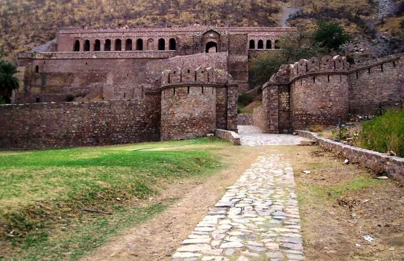
According to legend, a sadhu lived within the fort area, and according to his injunction, any house built in the precinct of the fort should not be taller than his own, and if the shadow of any such house fell on his house, it would result in destruction of the fort town. When columns were added to the fort that cast a shadow on the sadhu’s house, the result was destruction of the fort and surrounding towns.

According to another tale, Princess Ratnavati, the daughter of Chatr Singh, was considered to be the jewel of Rajasthan, such was her beauty. She received many proposals for marriage and had a number of suitors vying for her favour. Among those suitors was a local tantric who knew he stood no chance with the beautiful princess. In the market, Singhia saw the princess’s maid buying perfumed oil and seized his chance. He enchanted the oil so as soon as the princess would apply it, she would fall in love with him. Intimated about what happened, the princess threw out the oil, which fell on a boulder. The boulder was pulled towards Singhia and crushed him to death. However, with his dying breath, Singhia cursed the princess, her family, and the entire village around the Bhangarh Fort in Rajasthan. The very next year the entire population of Bhangarh is believed to have perished in a battle against Ajabgarh.

The Bhangarh Fort is located on the border of the Sariska Reserve in the Aravali range of hills in Alwar district of Rajasthan. The nearest village is Gola ka Baas. The fort is situated at the foot of the hills on sloping terrain. The ruins of the king’s palace are located on the lower slope of the hills; trees surround the pond area and a natural stream falls into the pond within the premises of the palace.

For more information (CC in English):

The sea of stars

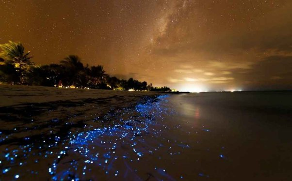
A beach in the Maldives known as Vaadhoo Island that shines at night creating a view that looks straight from science-fiction fairytale. It looks like the waves are decorated with Christmas lights, like millions of stars have crashed into the waves from above, glowing in the tide.

The glowing beach is located on Vaadhoo Island, one of the islands of Raa Atoll. This small island is inhabited by less than 500 people. Irrespective of its size and population, the beach island has earned global recognition and appreciation for its magical Sea of Stars. While the place has long been a secret, it now remains a must visit attraction for tourists visiting Maldives.

The natural phenomenon called ‘bioluminescence’ is because of a microorganism called phytoplankton or plankton. Because of their bioluminescent nature, these aquatic microbes radiate a vibrant blue light under sea. It’s almost like the stars have come down to embellish the sea. If mere view of the waves is not enough to delight your soul, you can even swim in the water. As you walk along the beach look behind to see your footprints in the glowing waters.

For more information :

The Bermuda Triangle

The Bermuda Triangle, also known as the Devil’s Triangle, is an urban legend focused on a loosely defined region in the western part of the North Atlantic Ocean where a number of aircraft and ships are said to have disappeared under mysterious circumstances. The idea of the area as uniquely prone to disappearances arose in the mid-20th century, but most reputable sources dismiss the idea that there is any mystery.

The earliest suggestion of unusual disappearances in the Bermuda area appeared in a September 17, 1950, article published in The Miami Herald by Edward Van Winkle Jones. Two years later, Fate magazine published “Sea Mystery at Our Back Door”, a short article by George Sand covering the loss of several planes and ships, including the loss of Flight 19, a group of five US Navy Grumman TBM Avenger torpedo bombers on a training mission. Sand’s article was the first to lay out the now-familiar triangular area where the losses took place, as well as the first to suggest a supernatural element to the Flight 19 incident

Natural explanations

Compass variations

Compass problems are one of the cited phrases in many Triangle incidents. While some have theorized that unusual local magnetic anomalies may exist in the area, such anomalies have not been found. Compasses have natural magnetic variations in relation to the magnetic poles, a fact which navigators have known for centuries. Magnetic (compass) north and geographic (true) north are exactly the same only for a small number of places – for example, as of 2000, in the United States, only those places on a line running from Wisconsin to the Gulf of Mexico. But the public may not be as informed, and think there is something mysterious about a compass “changing” across an area as large as the Triangle, which it naturally will.

Human errors

One of the most cited explanations in official inquiries as to the loss of any aircraft or vessel is human error. Human stubbornness may have caused businessman Harvey Conover to lose his sailing yacht, Revonoc, as he sailed into the teeth of a storm south of Florida on January 1, 1958.

Violant weather

Hurricanes are powerful storms that form in tropical waters and have historically cost thousands of lives and caused billions of dollars in damage. The sinking of Francisco de Bobadilla’s Spanish fleet in 1502 was the first recorded instance of a destructive hurricane. These storms have in the past caused a number of incidents related to the Triangle. Many Atlantic hurricanes pass through the Triangle as they recurve off the Eastern Seaboard, and, before the advent of weather satellite, ships often had little to no warning of a hurricane’s approach.

A powerful downdraft of cold air was suspected to be a cause in the sinking of Pride of Baltimore on May 14, 1986. The crew of the sunken vessel noted the wind suddenly shifted and increased velocity from 32 km/h (20 mph) to 97–145 km/h (60–90 mph). A National Hurricane Center satellite specialist, James Lushine, stated “during very unstable weather conditions the downburst of cold air from aloft can hit the surface like a bomb, exploding outward like a giant squall line of wind and water.” A similar event occurred to Concordia in 2010, off the coast of Brazil.

For more information :

Reed Flute Cave

It is widely believed that the cave sat empty and untouched for a thousand years, before its rediscovery in 1940’s by a group of refugees, fleeting Japanese Troops. 20 years later, the cave was formally opened to the public (1962). Since then it has become an extraordinary popular tourist attraction with people from all over the world. Even the former Chinese government leader Deng Xiaoping, former US presidents Nixon and Carter, and former UN Secretary-General De Quillar have visited the cave.

While stepping out of the cave, you will find the abundant reeds that grow and thrive outside the mysterious cave, which can be used to make flutes, and that is how the cave was named. Just close your eyes and imagine yourself standing in the mist of the reeds and get refreshed, breathing the fresh air and catching the gentle whistling of the flute. Outside the cave, it’s a perfect tranquil hermitage where China’s “Thoreau” may live.

Reed Flute Cave is a spectacular cave located in Guilin City. Walking into Reed Flute Cave, you will be amazed at how radiant the dewy stalagmites look like. The rainbow lights and dazzling array of massive natural formations compose a dreamy wonderland. The underground lake peacefully flows along the cave, with the reflection of the cave veiling on the river and flowing quietly with the stream, which makes the beauty even more vivid and dynamic. The interior of Reed Flute Cave is a sight that can not be recreated anywhere else on earth and these distinctive formations have names that match their appearance, and some are said to resemble mythological creatures or modern structures like the Statue of Liberty.

For more information :

The Skaftafell – The blue ice cave

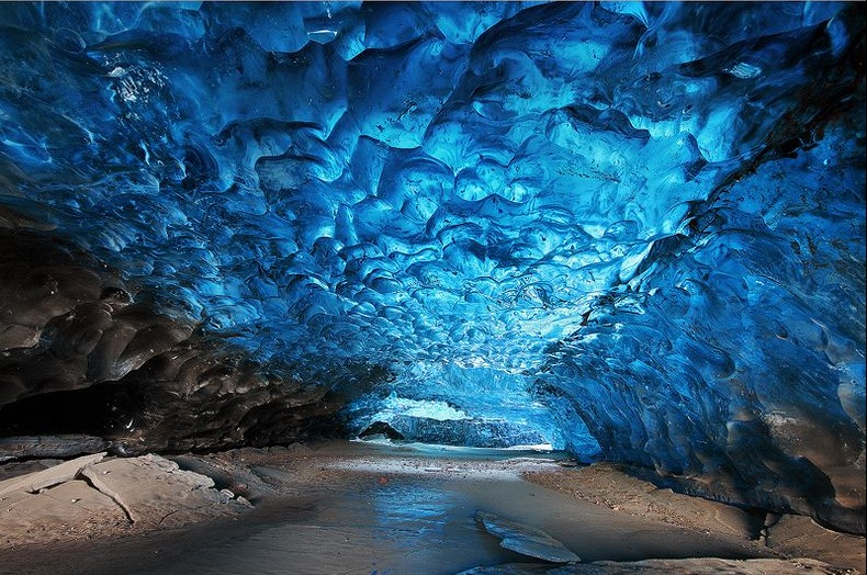
Skaftafell blue ice cave is located on the tongue of Vatnajökull, the largest glacier in Europe. It is also home to the tallest peak of Iceland – Hvannadalshnúkur. While the glacier is one of the most accessible glaciers in the country but the blue ice cave of this glacier is one of the hardest to reach in the country. A camera is a must bring for your trip. There is no doubt that you will want to capture every single thing that you witness in the cave.

The thing that makes ice caves so exclusive is that they are ever-changing. There is a fair chance that the formations and structures that you see on your first trip are completely different then what you get to witness on your next trip. The ice caves are a dynamic natural phenomenon that is formed when glacial rivers cut through the glacier and form a cave-like structure in the middle. These are generally accessible during winters only. The blue ice cave forms almost every season while most caves do not. Although the cave doesn’t need to form in the same place every time – they change places along with structure. This means not only the thrill and adventure of the harsh glacier but also the mystery of finding the caves.

For more information :

Best parts : 7:00 – 8:00

Fingal’s cave

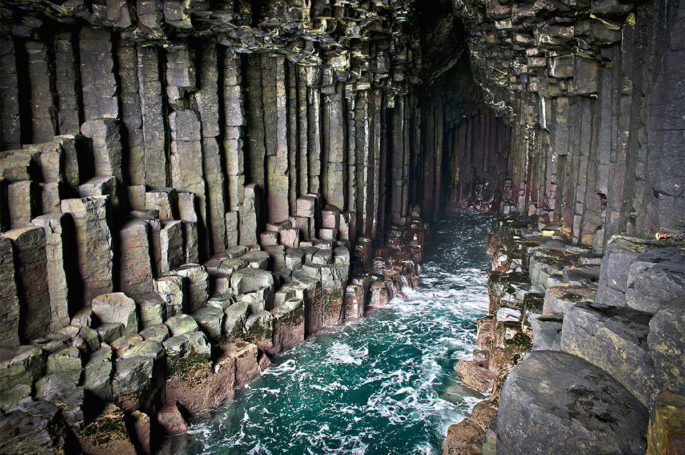
Fingal’s Cave was originally part of the Ulva estate of the Clan MacQuarrie from an early date until 1777. The cave was brought to the attention of the English-speaking world by 18th-century naturalist Sir Joseph Banks in 1772.

It became known as Fingal’s Cave after the eponymous hero of an epic poem by 18th century Scots poet-historian James Macpherson. It formed part of his Ossian cycle of poems claimed to have been based on old Scottish Gaelic poems. In Irish mythology, the hero Fingal is known as Fionn mac Cumhaill, and it is suggested that Macpherson rendered the name as Fingal (meaning “white stranger”) through a misapprehension of the name which in old Gaelic would appear as Finn. The legend of the Giant’s Causeway has Finn (or Fionn) building the causeway between Ireland and Scotland.

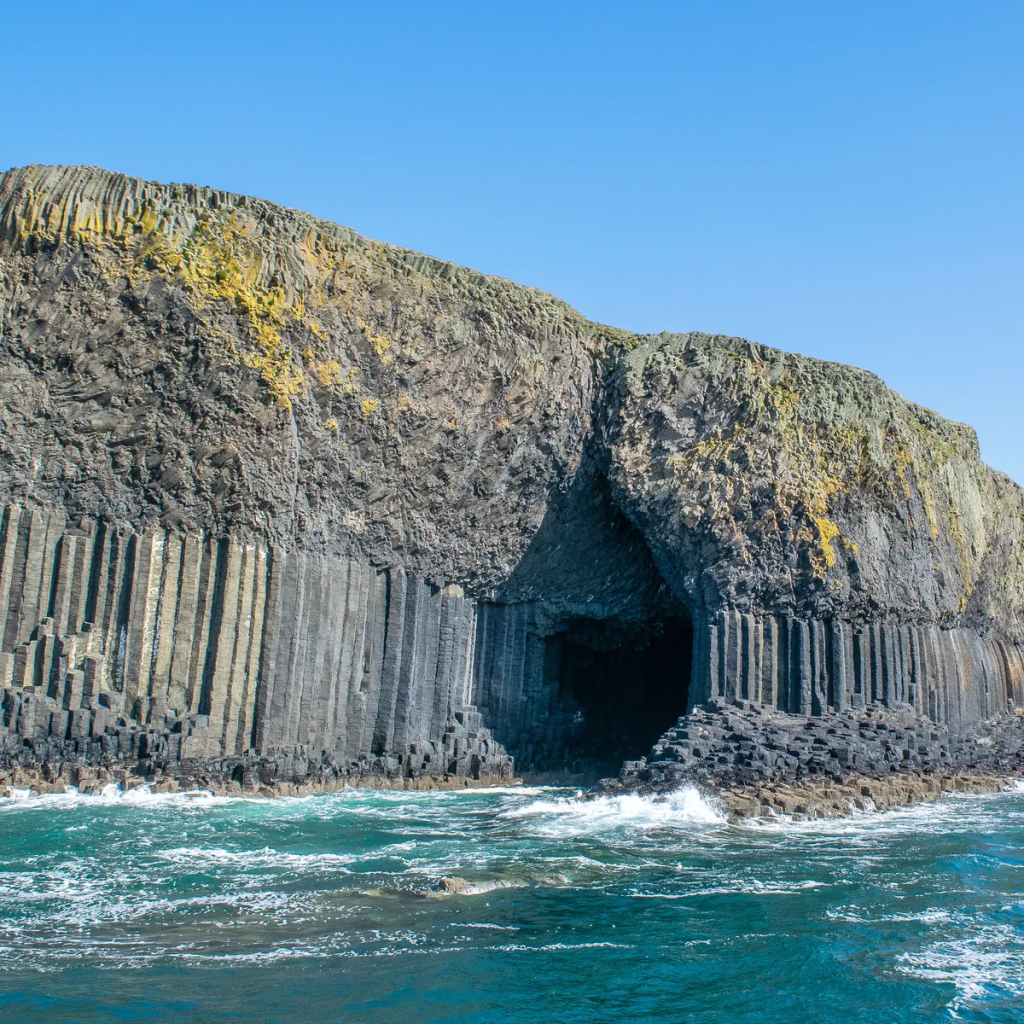
Fingal’s Cave is a sea cave on the uninhabited island of Staffa, in the Inner Hebrides of Scotland, known for its natural acoustics. The National Trust for Scotland owns the cave as part of a national nature reserve. It became known as Fingal’s Cave after the eponymous hero of an epic poem by 18th-century Scots poet-historian James Macpherson.

Fingal’s Cave is formed entirely from hexagonally jointed basalt columns within a Paleocene lava flow and is similar in structure to both the Giant’s Causeway in Northern Ireland and Ulva.

In these locations, cooling on the upper and lower surfaces of the solidified lava resulted in contraction and fracturing, starting in a blocky tetragonal pattern and transitioning to a regular hexagonal fracture pattern with fractures perpendicular to the cooling surfaces. As cooling continued these cracks gradually extended toward the center of the flow, forming the long hexagonal columns we see in the wave-eroded cross-section today. Similar hexagonal fracture patterns are found in desiccation cracks in mud where contraction is due to loss of water instead of cooling.

For more information :